Staying ahead of the competition in the fast-paced sales world requires more than a great product or service. It demands strategic planning, efficient communication, and a deep understanding of your target audience. Salesforce Maps emerges as a powerful tool in the arsenal of businesses aiming to streamline their sales processes and enhance their overall performance.
Understanding Salesforce Maps
Salesforce Maps is an innovative solution designed to empower sales teams by providing visual insights into their data. It leverages the power of location intelligence and geospatial CRM data to create interactive maps that enable businesses to optimize their field operations, enhance territory management, and drive better decision-making.
Good to know: Salesforce Maps was formerly called Map Anything.
Salesforce Maps tool is an add-on for Salesforce Sales Cloud (versions Professional and above) that has two levels of features and pricing depending on the business and sales needs.
Core Salesforce Maps
The Standard edition of Salesforce Maps starts with a price tag of $75 per user license per month, depending on your Sales Cloud version. This edition provides the following features:
- CRM Data Visualization,
- routes optimization and weekly scheduling,
- territory management and lead auto-assignment,
- mobile access.
Salesforce Maps Advanced
The Advanced edition of Salesforce Maps enhances the Core version by incorporating more intricate features. Pricing begins at $125 per user license per month, varying based on your Sales Cloud version. This version offers the following supplementary functionalities:
- automation of route planning for up to 4 months,
- complex priority scheduling based on business rules and constraints,
- data trends with thematic maps.
Addons
Salesforce Maps Live Tracking
In addition to Core and Advanced packages, Salesforce offers a Live Tracking addon that provides continuous updates on the current location of field representatives and other assets, enabling managers and teams to have instant visibility into their activities.
Good to know: SF Maps Live Tracking can obtain location from any phone with an installed Salesforce Maps App (with tracking option turned on) or a supported IOT device.
Salesforce Maps Territory Planning
Territory Planning in Salesforce Maps extends basic shape layers functionality, allowing the creation, import, and publishing of hierarchical group territories based on data samples, manual input, or Enterprise Territory Management. This tool also allows users to generate reports and analyze the performance of each territory, identifying trends, opportunities, and areas for improvement.
Integration between SF Maps and ETM can up territory planning significantly by:
- automatic import of territory data model directly to Salesforce Maps from Territory Management,
- publishing new or updated versions of territory data model from SF Maps to Territory Management,
- assigning accounts, leads, or opportunities to specific territories based on predefined criteria.
Unveiling the essentials of Salesforce Maps
Data visualization
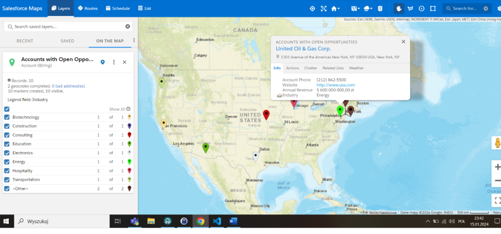
Data visualization in Salesforce Maps involves representing Salesforce CRM data (using address latitude and longitude fields) on interactive maps, providing users with a visually intuitive way to analyze and understand geographic and spatial information.
Good to know: Salesforce Maps can connect and visualize data from ArcGIS Online, making it even more powerful.
Users with the correct permissions can create predefined map views organized in folders called layers. Access to the layers can be:
- public if it is saved in the Corporate folder,
- private in Personal folder.
Layers can contain different types of information, be displayed in many different ways as markers, shapes, or plain data, and be related to salesforce objects (defined as base objects in app settings).
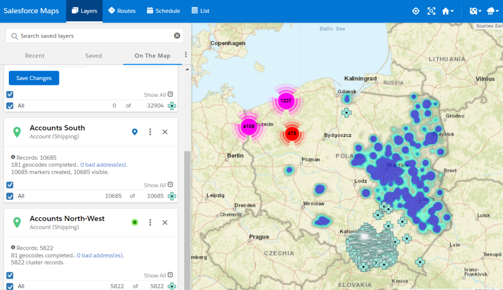
During the creation of the layer, the user can fully customize what data is displayed (any number of fields and related objects can be selected) and how it is shown in Salesforce Maps. Markers can change in shape, size, or color based on defined criteria; they can be later displayed as clusters or heatmaps.


Routes planning
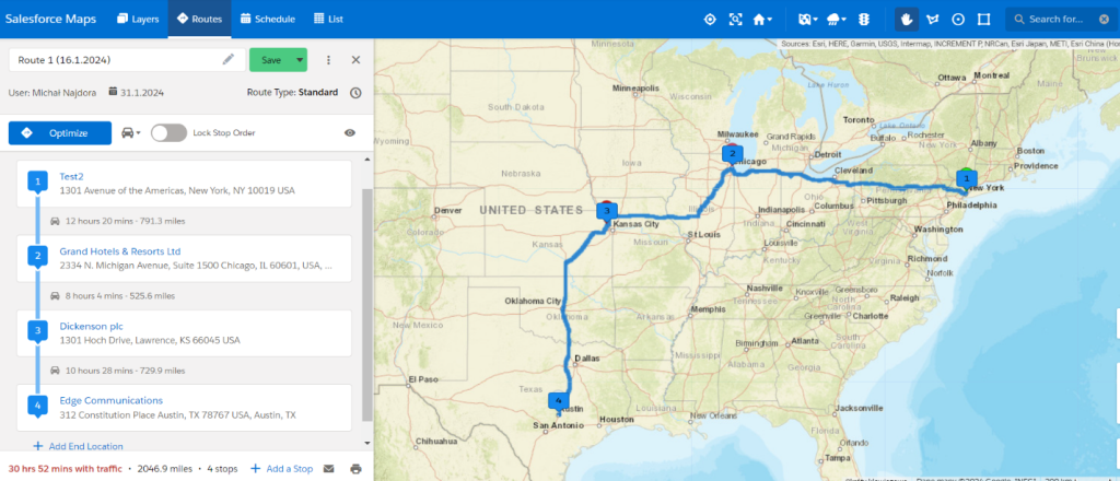
Route planning is a critical component within the Salesforce Maps ecosystem, playing a pivotal role in enhancing the efficiency and productivity of field representatives. This feature provides users a versatile and intuitive platform to plan and optimize their travel routes strategically, ensuring that sales visits are conducted most effectively and time-consciously.
Users are empowered with multiple options for adding destinations to their routes. Whether inputting individual locations, drawing custom shapes on a map, or aggregating all records from a designated territory, Salesforce Maps offers a flexible and user-friendly approach to defining the scope of a journey.
The tool leverages a provided list of locations to intelligently optimize the sequence of destinations while allowing users to fine-tune the order based on specific preferences or circumstances. Once optimized, a route can be directly saved into the Sales Representative’s calendar, providing a centralized and synchronized view of scheduled visits.
Users can choose their preferred transportation mode, be it driving, walking, or cycling, tailoring the route planning process to specific needs. Additionally, the tool allows for the creation of standard or time-based routes and the addition of any extra stops en route.
Furthermore, route creation is feasible from a calendar perspective, where users can schedule appointments. The system can automatically generate and optimize routes, plan breaks, or suggest supplementary stops based on these events.

Territory Management
Salesforce Maps Territory Management is an easy-to-use feature designed to optimize and manage sales territories within the Salesforce platform.
Good to know: The Territory Planning Add-on enhances essential territory management by introducing numerous beneficial features such as hierarchical groups, creation from datasets, and more.
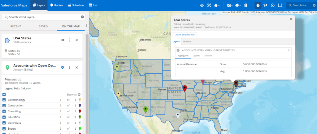
Basic Territory Management utilizes Shape Layers to create territories based on predefined lists for each country or country.
It is worth mentioning that any number of predefined areas (with a different granularity – the user can choose whole states, cities, or just a few zip codes) can be selected from a list or by drawing directly on a map.
More additional filter conditions can be provided to limit the number of territories. Plotting on a map allows users to show only those markers inside a given territory, hide or show area borders, and even display summary reports based on preselected grouping fields.

Salesforce Maps Advanced
Salesforce Maps Advanced introduces more sophisticated route planning and prioritized scheduling by expanding on the foundational version. The following concepts have been implemented to enhance route planning:
- Visit Plans are templates for constructing routes and consolidating all route requirements into one location. Visit plans enable the easy regeneration of routes with the same criteria, accommodating changes in your calendar. They encompass routable objects representing accounts or visits, a list of representatives performing the visits, start and end dates, and settings like shift times.
- Visit Windows – these represent timeframes during which a customer or prospect is open to visits from a representative. Visit windows can specify particular days of the week or specific hours during the day. Specifying visit windows in visit plans allows Salesforce Maps Advanced to schedule all future visits within these defined timeframes. In cases where visit windows are not limited, visits are organized within the representatives’ working hours and the visit plan start and end dates.
Additionally, Salesforce Maps Advanced introduces various settings and enhancements:
- warnings for overlapping appointments,
- exclusion of specific events from schedules,
- customizable maximum drive time,
- customizable optimization speed for ad hoc changes.
Tips for admins & developers
Obtaining a test version of SF Maps
Securing Salesforce Maps for testing or demonstrations may pose challenges at times. In addition to the conventional method of reaching out to a Sales Representative for access to a trial version of Salesforce Maps, there are a few “tricks” that enable testing without the necessity of reaching out to anyone:
- create development org with preinstalled Salesforce Maps,
- install the Salesforce Maps package using the SFDX command: sf package install –package 04t4P000002GKHOQA4
Salesforce Maps Limits
As with every platform tool, Salesforce Maps has some governor limits and constraints. Here is a list of the most common ones:
| Route planning period | 1 week for the Core & 4 months for the Advanced version |
| Max daily events for scheduling | 120 |
| Max number of waypoints with traffic | 150 |
| Max number of waypoints for time-based route | 120 |
| Max distance between waypoints in pedestrian mode | 5km (3.1 miles) |
| Max markers plotted on desktop | 5 layers at once for up to 50000 markers (250000 total) |
| Max markers plotted in mobile | 1000 markers |
In addition, indicate:
- While using Screen Flow inside Salesforce Maps on mobile, lookup fields won’t display options.
- While using Screen Flow or LWC inside Salesforce Maps, popups and events won’t be displayed as the event panel is not currently supported inside this tool.
- External object limitations available on the website.
Accredited Professional Certification
Salesforce Maps takes part in the Accredited Professional Certification program, allowing you to expand your knowledge about the product and become a Salesforce Maps specialist. If you are interested in becoming certified, look at the Accredited Professional Exams website.
Want to know more?
If my article got you interested in Salesforce Maps, here are some additional resources that you can learn more about and even become a certified Salesforce Maps Accredited Professional:
***
If you are interested in other tools used in the IT industry, be sure to take a look at our experts’ articles.


Leave a comment